Dubai, a city known for its awe-inspiring skyscrapers, luxurious lifestyle, and rich cultural heritage, boasts a transportation system that’s equally impressive. The Dubai Metro, with its sleek design, efficiency, and extensive network, is a lifeline for both residents and tourists. In this comprehensive guide, we’ll delve into the Dubai Metro Map, exploring its intricacies, advantages, and how it plays a vital role in the city’s transportation system.
Dubai Metro Overview: The Dubai Metro, launched in 2009, is a state-of-the-art, driverless metro system that connects key locations across the city. It is one of the most advanced and automated metro systems globally, boasting a clean, safe, and efficient mode of transportation.
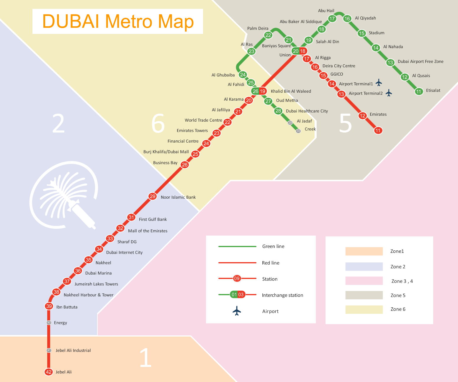
The Red and Green Lines: The Dubai Metro is primarily divided into two lines: the Red Line and the Green Line.
1. Red Line: The Red Line, often referred to as the backbone of the Dubai Metro, runs from Rashidiya in the north to Jebel Ali in the south. It spans approximately 52.1 kilometers and connects some of the city’s most iconic destinations, including Dubai International Airport, Mall of the Emirates, Dubai Marina, and the Dubai World Trade Center.
2. Green Line: The Green Line stretches from Etisalat in the north to Creek in the south, covering a distance of approximately 22.5 kilometers. It intersects with the Red Line at two major transfer stations: Union Square and BurJuman. The Green Line provides easy access to Deira, Dubai Creek, and historic areas like Al Fahidi and Al Bastakiya.
Expansion Plans: Dubai Metro’s continuous expansion reflects the city’s commitment to providing efficient public transportation. The future plans include the construction of additional lines and extensions, further improving connectivity across the city. One such project is the Dubai Metro’s extension to Expo 2020, enhancing accessibility to this global event.
Dubai Metro Map Features: Understanding the Dubai Metro Map is essential for navigating the city effectively. Here are some key features of the map:
1. Line Colors: The Red Line is marked in red, while the Green Line is represented in green. These distinct colors simplify navigation for both residents and tourists.
2. Station Names: Each station on the map is clearly labeled, making it easy to identify your desired stop.
3. Interchange Stations: Interchange stations, where the Red and Green Lines intersect, are vital points for transferring between lines. These include Union Square and BurJuman.
4. Icons: Icons are used to highlight key landmarks near metro stations, such as shopping malls, government offices, and tourist attractions. This feature aids in planning journeys around specific destinations.
Advantages of Using the Dubai Metro: The Dubai Metro offers numerous advantages to its passengers:
1. Accessibility: The metro is designed to accommodate individuals with disabilities, ensuring inclusivity.
2. Reliability: The metro is known for its punctuality and adherence to schedules, making it a reliable mode of transportation.
3. Cost-Effective: Compared to other transportation options, the Dubai Metro is cost-effective, especially for daily commuters.
4. Safety: The Dubai Metro is considered one of the safest transportation systems globally, with advanced security measures in place.
5. Environmental Impact: The metro system contributes to reducing traffic congestion and pollution, aligning with Dubai’s sustainability goals.
Conclusion: The Dubai Metro Map is not just a navigation tool but a testament to Dubai’s commitment to providing efficient, modern, and environmentally friendly transportation. Whether you’re a tourist exploring the city’s iconic landmarks or a resident commuting to work, the Dubai Metro plays a crucial role in making Dubai accessible, convenient, and sustainable. Understanding the Dubai Metro Map is the first step towards experiencing all that this vibrant city has to offer.